 Typical image provided
 The weather forecast for environmental monitoring (weather forecasting popular), is based on the analysis of the type:
Wind (orientation and type)
Clouds (One or more heights. At the same or different speeds in each layer. "cotton" rounded "clusters" or "hair". Blancas or very dense and blackened-clusters congestive-).
Air humidity (by the behavior of animals and some plants) ...
 When approaching rain Some trees will make teaching the underside of the leaves at the end and at the end of the cup (1). Trees often require large amounts of water for development (not true of all types that occur in these environments (2)). Is the moisture-laden air and the drop in atmospheric pressure which probably induces this peculiar behavior and safe
 N e, we add new items to help us in our prediction and to determine the duration of a particular weather conditions:
Barometer (measures in addition to its value-which is the least important, the behavior of atmospheric pressure over time),
Hygrometer (measures humidity, the less important, and this variation over time).
general movement of the clouds ( and therefore the wind) that the State Agency of Meteorology, offers as a sequence of sequence of satellite images.
We must not look too, for what concerns us in their local forecasts and whether the movement of clouds and, therefore, the winds present to make the images so you can anticipate the future in the coming hours or days .
 A simple and economic barometer (in this case weather station) will be enough to help us in our prediction. analog indicators, should know to be used because otherwise the reading, it is absolutely wrong.
 Our forecasts secure, you have to be made unanimously by the results of observation of all these elements . Locally there are many conditions that can make a general prediction err and, therefore, the attention should be taken into account unanimity results in a same direction, the prediction by observation of the environment.
P prediction that any other officer, is impossible to rain in Madrid in the coming hours, looking white clouds "fluffy" with low speed in a single layer (height), wind northeast, the barometer steady, swallows they hunt insects at the level used (relative humidity in the air, normal for the place), hygrometer static and poplars with leaves that retain their natural position
 Despite clearing skies, Announce poplars moist air and / or fall of the barometer, showing the underside Silvery leaves on the tip of the glass. If this occurs only indicative, not definitive in our prediction and must be confirmed by others, to show us the environment
 D and otherwise, also in Madrid, looking southwest winds, two layers clouds moving at different and considerable speed (especially the bottom), with the upper leaves of the poplars with the back towards the top, with a barometric descent accused in one day, we can ensure that bad weather is approaching with rain and electrical , forthcoming and estimated duration of 12 hours (in this situation must be confirmed that " lollipop, "telecommunications antenna of this city is covered with clouds to ensure, in this case, it will rain in minutes). We can hardly miss with the observed data
WINDS IN THE IBERIAN PENINSULA
E he fact that wind does not appear necessarily imply a worsening of the time (which usually happens at sea) but depending on their origin, can indicate a change.
L you have to observe winds in two ways: generically, as the animations of the meteorological service, and locally, according to the movement of the clouds (not to ground level places other than sea port, because in many cases, we have confusion, the wind has to be valued at the height of the clouds in the direction and moving this way.)
A general level can be classified into four types according to the guidelines made there: North-Northeast / South-East / West-South / North-West
The North-Northeast usually appear with an anticyclone (high pressures) Atlantic north of Europe, along with a storm (low pressure) located in northern Africa. They are cool or cold winds with low humidity (hard rain), but responsible for the cold wave peninsula. Examples: gale (Duero Basin), north winds (Catalonia). Summary: no excessive speed but usually cold or very cold.
On the north coast of Spain (not inside), are usually responsible for the clear weather, but cold and the sea "bucking." In Madrid, they often produce anything but cold ... but with clear skies.

misuse of analog gauges, indicators and . Given the tensions and frictions they present, the reading will always be wrong if you do not strike so light and settled for reading. In this way the tensions and frictions mentioned not prevent, despite its status as a "cheap", its perfect and precise operation.
The South-East . Coming from the south, are dry and warm, so they tend to indicate time embarrassing. Those from the East are very wet and therefore can cause very heavy rain. In Madrid the incidence is usually whitish, flat sky with a feeling of embarrassment, the light absolutely flat, even with the sun overhead worst thing for architectural photography!
The South-West usually corresponding to the entry of a storm from the Atlantic, near the Gulf Cadiz, combined with an anticyclone over Italy: Rain insured much of the peninsula, except in northern Spain who enjoyed hot days (with or without clouds, but absolutely never with rain).
winds from Toledo, bring rain storm in Madrid secured with relatively strong winds.
North-Northwest. are more typical in winter. Are mild and wet (those from the west) in the north of the peninsula, which produce large amounts of rain, dry and cold (those from North) in the other (north wind in Aragon, mestral in Catalonia, Galician in the basin Ebro). In the north of the peninsula are characteristic of gale on the coast and are usually high speed.
in Madrid, are usually cold, but very intermittent heavy rain. Are responsible for the skies with dark clouds interspersed with clear skies, great for landscape and architecture.
These winds (corresponding to this classification by orientation) are often the most characteristic in our country.
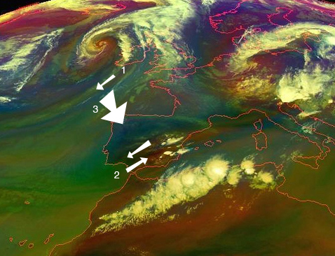
interpretation of an image weather. Typical storm located off the coast of northern Europe which will bring fresh winds (cold northeastern winter) (1). The front of clouds moves to the northwest peninsula (3), so bad weather will affect widespread north of the peninsula (on the northeast coast blew and therefore, by the day, cool weather and clear ) and falling temperatures. Good weather for the rest of the peninsula, but .... an anticyclone over Italy, making winds blow in the southwestern Mediterranean (2), which were formed by rain, possibly heavy at these sites (part of Andalusia and Catalonia). This is the typical situation called for "cold drop" that usually occurs in post summer months, in the Mediterranean (late August and September)
To calculate the time it affected an area of \u200b\u200bstudy is the speed at the animated map and confirmation with the barometer. Later
after 24 hours (depending on how fast the storm moves) generally favorable weather throughout the peninsula except in the north (on the Cantabrian coast blew northeast during the day and will remain sunny and cold)
This interpretation is not worth much if the conclusions are not confirmed by other environmental elements that indicate whether the first predictions are somewhat unreliable, these are the really important while the primary is rather indicative ...
E s curious to see how the winds in upper layers of the atmosphere (cloud level) are presented as will advance to the ground, so that having a calm air at ground level and moving south of the clouds, we can ensure that in a certain period of time appeared similar wind at ground level. This feature relies almost all popular customs relating to the observations for weather forecasting and environmental monitoring.
End of Part
Part Three: The barometer. Your use and precise interpretation